Okavango Flood update - March 20, 2009
 Friday, April 3, 2009 at 10:13AM
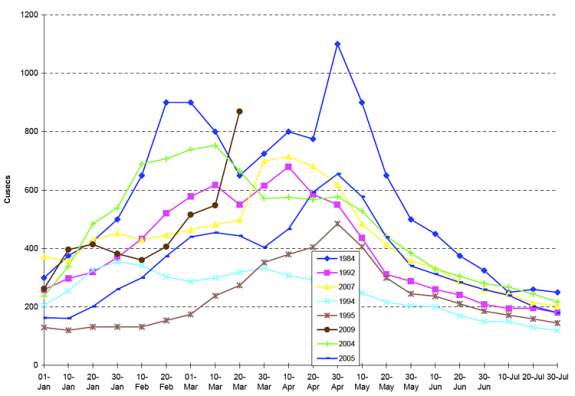
 The following chart shows the levels of the 2009 Okavango flood waters. Map Ives, Wilderness Safaris' Chief Ecologist, sums up the flood so far... interesting stuff!
It is that time of year when the data is coming in thick and fast from hydrologists throughout southern Africa regarding the state of flows in our rivers, and the environmental and social effects of those flows. This includes data from the water authorities in Namibia, Angola, Botswana and Zambia outlining the scenarios for the Kunene, Zambezi, Kwando, Kavango and Kuito rivers (The last two combine to form the Okavango River upstream of the delta proper).
There have been a number of reports in the news media which may have created a negative impression of the “flooding”, which indeed has affected a small number of people on a localized basis, but in fact has a positive effect on the ecology of the natural areas into which they flow.
Due to a combination of higher than normal Indian Ocean temperatures, a low pressure system centred over central Botswana and a southward movement of the moist Congo Air Boundary, the late summer rains have been well above average. This has been particularly so over the 16 Degrees South latitude in a band across the African Continent and which, fortuitously, include the catchments of some of the great rivers of south central Africa mentioned in the first paragraph. During the first two weeks of March, this band received about 120% above average rainfall, followed by localized but heavy falls along the Zambia/Angola border region as well as over the Okavango Delta itself.
All of this has resulted in river flows that are above average as measured over the last 70 years. This is not unusual in the long term, as flows such as these have been recorded before, and in fact are well placed into data sets that show a pattern of wet and dry cycles over the entire catchment area. However, in the short term, this has resulted in flows that have not been seen in the Zambezi and Okavango Rivers since 1963.
These effects of this increased runoff on downstream environments will vary tremendously between those felt by people who have moved into low lying areas during the “dry” years, and those felt by the natural environments such as the Okavango, Savute/Chobe and Zambezi environments. Extremely high levels of water have inundated parts of the panhandle area of the Okavango, the area between the Chobe and the Zambezi, and floodplains along all these rivers. However, it must be stressed that no lives have been lost and so called flooding has only occurred in areas that have historically been floodplains. People have been assisted with evacuation to temporary shelter on higher ground nearby, where they will probably only stay for about 8 to 10 weeks before the waters subside.
Lower down the Okavango River and into the delta itself, the effects will be fantastic, as large grassland areas and floodplains which have not been inundated for many years and even decades, become flooded, and a complete recharge of groundwater takes place. Islands which have been dehydrated through no ground water flows, will now rejuvenate and distal lakes such as Ngami and Mababe will fill. These two terminal sinks along with a major increase in flows down the Boteti create wide ranging habitats for many, many waterfowl and mammal species. Linked to the Mababe Lake and fed from the Linyanti/Kwando system the Savute Channel can be expected to have a major increase in flows, which may well result in the re-establishment of the famed Savute Marsh at the terminal end of the channel. The availability of so much water over a large area will have extremely beneficial effects on the distribution of the region’s high elephant numbers.
Most, if not all of the camps in the Okavango are situated on islands and higher ground with many being on lifted walkways and stilts. There should be little if any, effect on the camps themselves, although some camps may have to adjust the road networks somewhat since many were located during those dry years. This is in fact a natural phenomenon which only happens very occasionally in the wet and dry cycle as mentioned, and is a grand opportunity to see the rivers and deltas of the region in all their glory.
After nearly 30 years of low flows, interspersed with occasional average flows, we now have a near record inflow, the effects of which are too many to innumerate here, but suffice to say are hugely important to the biodiversity of the Okavango and the region in general.
Those of us who have lived and worked here for many years have waited for a year so special as this, come and join us, it will happen only once in a lifetime.
Map Ives
Wilderness Safaris Botswana
26th March, 2009.
The chart below shows data as of March 20, 2009.


